📌 TOPINDIATOURS Breaking ai: 2,000-year-old Bruchhauser Stein was ritual site of ‘
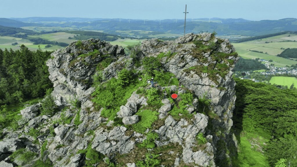
A fortified settlement once found itself here, on a scenic hillfort in Germany known as Bruchhauser Steine. High above the forests of the Sauerland, though a popular hiking spot today, individuals from the Iron Age decided to fortify this location with rocks, but why these Iron Age men would secure the mountain puzzled archaeologists.
Chief archaeologist of a new study, Sandra Peternek, explained in a press release by LWL, that “the Bruchhauser Steine are situated in a location unfavorable for settlement, significantly removed from the preferred settlement areas along the Hellweg trade route. They are frequently exposed to challenging weather conditions.”
A site of mystery and intrigue, archaeologists suspected that this hillfort might have held religious significance. Back in 2013, archaeologists found an arm ring and a deliberately damaged spearhead, which encouraged this hypothesis to take shape.
Now, in 2025, local historian Matthias Dickhaus announced yet another extraordinary find: two iron axes whose blades were aligned at right angles to each other. Stunned by the sight, he contacted the LWL Archaeology department immediately, who then found socketed axes, or Tüllenbeile, as per LBV.
Beneath them, they discovered a thrilling piece of evidence substantiating the developing theory — maybe closer to fact now— that Bruchhauser Steinewas a place of worship: a quartz pit.
New evidence of ritual at Bruchhauser Steine
In this remarkable pit, which had been carved into the rock and sealed with soil, archaeologists uncovered quartz. A flat stone slab and a rounded stone, known as a Pochstein, a hammer or crusher, to break these materials up, all began communicating a story to archaeologists that this was a hillfort that they protected because it held a symbolic and religious purpose, as per LBV.
In a press release, LWL Archaeology described the find as “exceptional” because quartz could have been mined at the base of the rock. However, they, intriguingly, sourced it elsewhere. These Iron Age men and women instead decided to mine quartz from this elevated location, near the “Otherworld,” which refers to the realm beyond life, inhabited by gods or spirits in Celtic mythology. Quartz was even utilized in Iron Age pottery.
“It is conceivable that the quartz from the fieldstone was an ingredient in special, perhaps ritual, vessels,” as per a press release.
Making history accessible
“Here, we are witnessing ritual acts on one of the landmark’s most exposed rocks: People mined quartz, crushed it, and finally, the ‘wound in the mountain’ had to be sealed again,” Dr. Manuel Zeiler said, from the LWL Archaeology. “The laying of two axes on the ground solemnly concluded the ritual.”
Researchers were able to interpret what the ritual consisted of based on the construction of this remarkable pit.
As a site of increasing importance, the Brücke-Hausen Steine Foundation announced that it intends to make the new findings accessible to the public in a new display case.
“Communicating new archaeological findings is a major priority…,” Nadja de Pierpont-Freifrau von Fürstenberg, chairwoman of the foundation, concluded in a press release. “We can present current research and integrate the cultural heritage into our museum’s presentation of geology and nature.”
“We are proud not only to preserve and make accessible to the public one of the most extraordinary hillforts in North Rhine-Westphalia, but also that new archaeological pieces of the puzzle are gradually revealing our understanding of the past.”
🔗 Sumber: interestingengineering.com
📌 TOPINDIATOURS Hot ai: ByteDance Introduces Astra: A Dual-Model Architecture for
The increasing integration of robots across various sectors, from industrial manufacturing to daily life, highlights a growing need for advanced navigation systems. However, contemporary robot navigation systems face significant challenges in diverse and complex indoor environments, exposing the limitations of traditional approaches. Addressing the fundamental questions of “Where am I?”, “Where am I going?”, and “How do I get there?”, ByteDance has developed Astra, an innovative dual-model architecture designed to overcome these traditional navigation bottlenecks and enable general-purpose mobile robots.
Traditional navigation systems typically consist of multiple, smaller, and often rule-based modules to handle the core challenges of target localization, self-localization, and path planning. Target localization involves understanding natural language or image cues to pinpoint a destination on a map. Self-localization requires a robot to determine its precise position within a map, especially challenging in repetitive environments like warehouses where traditional methods often rely on artificial landmarks (e.g., QR codes). Path planning further divides into global planning for rough route generation and local planning for real-time obstacle avoidance and reaching intermediate waypoints.
While foundation models have shown promise in integrating smaller models to tackle broader tasks, the optimal number of models and their effective integration for comprehensive navigation remained an open question.
ByteDance’s Astra, detailed in their paper “Astra: Toward General-Purpose Mobile Robots via Hierarchical Multimodal Learning” (website: https://astra-mobility.github.io/), addresses these limitations. Following the System 1/System 2 paradigm, Astra features two primary sub-models: Astra-Global and Astra-Local. Astra-Global handles low-frequency tasks like target and self-localization, while Astra-Local manages high-frequency tasks such as local path planning and odometry estimation. This architecture promises to revolutionize how robots navigate complex indoor spaces.
Astra-Global: The Intelligent Brain for Global Localization
Astra-Global serves as the intelligent core of the Astra architecture, responsible for critical low-frequency tasks: self-localization and target localization. It functions as a Multimodal Large Language Model (MLLM), adept at processing both visual and linguistic inputs to achieve precise global positioning within a map. Its strength lies in utilizing a hybrid topological-semantic graph as contextual input, allowing the model to accurately locate positions based on query images or text prompts.
The construction of this robust localization system begins with offline mapping. The research team developed an offline method to build a hybrid topological-semantic graph G=(V,E,L):
- V (Nodes): Keyframes, obtained by temporal downsampling of input video and SfM-estimated 6-Degrees-of-Freedom (DoF) camera poses, act as nodes encoding camera poses and landmark references.
- E (Edges): Undirected edges establish connectivity based on relative node poses, crucial for global path planning.
- L (Landmarks): Semantic landmark information is extracted by Astra-Global from visual data at each node, enriching the map’s semantic understanding. These landmarks store semantic attributes and are connected to multiple nodes via co-visibility relationships.
In practical localization, Astra-Global’s self-localization and target localization capabilities leverage a coarse-to-fine two-stage process for visual-language localization. The coarse stage analyzes input images and localization prompts, detects landmarks, establishes correspondence with a pre-built landmark map, and filters candidates based on visual consistency. The fine stage then uses the query image and coarse output to sample reference map nodes from the offline map, comparing their visual and positional information to directly output the predicted pose.
For language-based target localization, the model interprets natural language instructions, identifies relevant landmarks using their functional descriptions within the map, and then leverages landmark-to-node association mechanisms to locate relevant nodes, retrieving target images and 6-DoF poses.
To empower Astra-Global with robust localization abilities, the team employed a meticulous training methodology. Using Qwen2.5-VL as the backbone, they combined Supervised Fine-Tuning (SFT) with Group Relative Policy Optimization (GRPO). SFT involved diverse datasets for various tasks, including coarse and fine localization, co-visibility detection, and motion trend estimation. In the GRPO phase, a rule-based reward function (including format, landmark extraction, map matching, and extra landmark rewards) was used to train for visual-language localization. Experiments showed GRPO significantly improved Astra-Global’s zero-shot generalization, achieving 99.9% localization accuracy in unseen home environments, surpassing SFT-only methods.
Astra-Local: The Intelligent Assistant for Local Planning
Astra-Local acts as the intelligent assistant for Astra’s high-frequency tasks, a multi-task network capable of efficiently generating local paths and accurately estimating odometry from sensor data. Its architecture comprises three core components: a 4D spatio-temporal encoder, a planning head, and an odometry head.
The 4D spatio-temporal encoder replaces traditional mobile stack perception and prediction modules. It begins with a 3D spatial encoder that processes N omnidirectional images through a Vision Transformer (ViT) and Lift-Splat-Shoot to convert 2D image features into 3D voxel features. This 3D encoder is trained using self-supervised learning via 3D volumetric differentiable neural rendering. The 4D spatio-temporal encoder then builds upon the 3D encoder, taking past voxel features and future timestamps as input to predict future voxel features through ResNet and DiT modules, providing current and future environmental representations for planning and odometry.
The planning head, based on pre-trained 4D features, robot speed, and task information, generates executable trajectories using Transformer-based flow matching. To prevent collisions, the planning head incorporates a masked ESDF loss (Euclidean Signed Distance Field). This loss calculates the ESDF of a 3D occupancy map and applies a 2D ground truth trajectory mask, significantly reducing collision rates. Experiments demonstrate its superior performance in collision rate and overall score on out-of-distribution (OOD) datasets compared to other methods.
The odometry head predicts the robot’s relative pose using current and past 4D features and additional sensor data (e.g., IMU, wheel data). It trains a Transformer model to fuse information from different sensors. Each sensor modality is processed by a specific tokenizer, combined with modality embeddings and temporal positional embeddi…
Konten dipersingkat otomatis.
🔗 Sumber: syncedreview.com
🤖 Catatan TOPINDIATOURS
Artikel ini adalah rangkuman otomatis dari beberapa sumber terpercaya. Kami pilih topik yang sedang tren agar kamu selalu update tanpa ketinggalan.
✅ Update berikutnya dalam 30 menit — tema random menanti!